How Multichannel GPR Helps Reduce Excavation Risk
Introduction
Excavation is a critical part of road construction, metro projects, utility installation, telecom work, pipeline repair, drainage development, and infrastructure maintenance. But every excavation site comes with one major risk: hidden underground utilities.
Below the surface, there may be power cables, telecom ducts, gas pipelines, water mains, sewer lines, drainage pipes, abandoned utilities, concrete structures, voids, and unknown buried objects. If these assets are not detected before digging, the project may face utility damage, safety hazards, service interruption, repair costs, legal issues, and project delays.
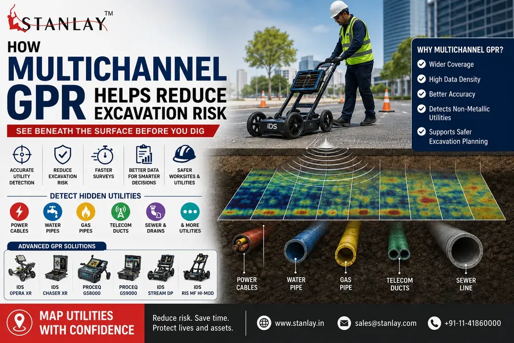
This is where multichannel GPR becomes highly useful. Multichannel Ground Penetrating Radar helps project teams scan the subsurface more efficiently and collect wider underground data in less time. It supports safer excavation planning by improving visibility of buried utilities and underground conditions before any digging begins.
This blog explains how multichannel GPR works, why it is useful for utility mapping, and how it helps reduce excavation risk in infrastructure projects.
What Is Multichannel GPR?
Multichannel GPR, or multichannel Ground Penetrating Radar, is an advanced subsurface scanning technology that uses multiple antenna channels to collect radar data across a wider survey area. Unlike single-channel GPR, which scans one line at a time, multichannel GPR can capture multiple parallel data lines in a single pass.
This makes it useful for large-area utility mapping, road surveys, urban infrastructure projects, airport works, highways, industrial sites, and municipal excavation planning.
Multichannel GPR is commonly used for:
Road and pavement investigation
Subsurface scanning before excavation
Detection of buried pipes and cables
Mapping unknown underground objects
Void detection
Infrastructure assessment
Pre-construction surveys
Smart city and municipal utility projects
Because it can collect dense subsurface data quickly, multichannel GPR helps teams make better decisions before excavation work starts.
Why Excavation Risk Is a Serious Concern
Excavation risk is not only about digging in the wrong place. It includes safety, cost, schedule, public disruption, and asset damage.
Common excavation risks include:
Damaging underground power cables
Breaking water or gas pipelines
Cutting telecom or fiber optic cables
Hitting sewer or drainage lines
Causing road collapse due to hidden voids
Delaying construction work
Increasing repair and reinstatement cost
Creating safety hazards for workers and the public
Disrupting essential services
In congested urban areas, these risks become even higher because underground utilities are often old, unmapped, poorly documented, or placed close to each other.
A proper subsurface survey helps reduce these risks before digging begins.
How Multichannel GPR Works
Multichannel GPR sends radar signals into the ground through multiple antennas. When these signals hit underground objects or changes in material, they reflect back to the system. The equipment records these reflections and creates subsurface data that trained operators can interpret.
The collected data may show:
Buried pipes
Cables and ducts
Drainage lines
Utility corridors
Concrete structures
Voids and cavities
Changes in soil layers
Unknown subsurface anomalies
The main advantage of multichannel GPR is that it scans a wider area with more data points. This gives a more complete view of the underground environment compared to a single scan line.
How Multichannel GPR Helps Reduce Excavation Risk
1. Provides Wider Subsurface Coverage
One of the biggest benefits of multichannel GPR is wider scanning coverage. Since multiple antenna channels work together, the system can collect data across a broader area in one pass.
This helps reduce the chance of missing utilities between scan lines.
For excavation projects, wider coverage means:
Better visibility of underground conditions
More complete utility mapping
Reduced blind spots
Faster survey of roads and corridors
Better planning before digging
This is especially useful for highways, metro corridors, airports, industrial plants, and large municipal roads where the survey area is wide.
2. Improves Utility Mapping Accuracy
Accurate utility mapping is essential before excavation. If underground utilities are not mapped properly, the excavation team may rely on outdated drawings, assumptions, or incomplete records.
Multichannel GPR improves mapping by collecting dense radar data across the site. This helps identify the position and direction of buried utilities more clearly.
It can support detection of:
Water pipelines
Sewer lines
Drainage pipes
Telecom ducts
Utility corridors
Unknown buried services
Non-metallic utilities, depending on site conditions
This helps project teams prepare better utility maps and reduce the risk of accidental strikes.
3. Helps Detect Non-Metallic Utilities
Standard electromagnetic cable locators are useful for metallic and conductive utilities. However, many underground assets are non-metallic, such as plastic pipes, concrete ducts, PVC conduits, and drainage lines.
Multichannel GPR can help detect non-metallic utilities by identifying radar reflections from buried objects and material changes. This makes it a useful technology for projects where utility records are incomplete or where non-metallic assets may be present.
This is important for:
Municipal water networks
Drainage systems
Smart city projects
Utility corridor mapping
Road expansion work
Industrial infrastructure
By detecting utilities that may not respond to electromagnetic locating methods, multichannel GPR adds another layer of safety before excavation.
4. Reduces Dependence on Trial Excavation
Without reliable subsurface data, teams may use trial pits or test digging to confirm underground conditions. While trial excavation may still be needed in some cases, relying only on it can increase time, cost, and site disruption.
Multichannel GPR helps reduce unnecessary trial excavation by giving a clearer picture of underground conditions before physical digging begins.
This can help:
Reduce unnecessary road cutting
Lower disruption in busy areas
Improve excavation planning
Minimize damage to existing assets
Reduce project delays
For city roads, commercial areas, and public infrastructure projects, this can save significant time and cost.
5. Supports Safer Excavation Planning
Excavation safety depends on knowing what is below the ground. Multichannel GPR provides information that helps engineers, contractors, and utility teams plan safer excavation routes and methods.
The data can help decide:
Where excavation should begin
Which areas need extra caution
Where utilities may be crossing
Which zones should be marked as high risk
Whether manual digging is required
Whether additional confirmation is needed
This reduces guesswork and improves decision-making at site level.
6. Speeds Up Large-Area Surveys
Single-channel surveys can take more time when the area is large. Multiple passes may be required to cover a road, corridor, or project zone. Multichannel GPR can scan wider sections faster, making it suitable for high-volume infrastructure projects.
Faster survey work is useful for:
Highway projects
Airport runway and apron surveys
Metro and railway corridors
Smart city utility mapping
Urban road redevelopment
Industrial plant expansion
Municipal infrastructure projects
When survey time is reduced, excavation planning can begin earlier and project timelines can be managed better.
7. Creates Better Data for Reporting
Excavation risk is not reduced only by detecting utilities. The survey data must also be documented clearly. Multichannel GPR supports better reporting because it collects dense data that can be reviewed, processed, and presented visually.
Useful reporting outputs may include:
Utility maps
Subsurface scan images
Depth estimates
Marked utility routes
Survey area records
Risk zones
Recommendations for excavation teams
Good documentation helps contractors, engineers, municipal bodies, and project owners understand what was found and what action should be taken.
8. Helps Identify Unknown Subsurface Conditions
Many excavation problems happen because the site contains unknown underground features. These may not be shown in drawings or old records.
Multichannel GPR can help identify unexpected subsurface features such as:
Abandoned pipes
Old utility lines
Buried chambers
Concrete blocks
Voids or cavities
Duct banks
Unknown anomalies
Identifying these before excavation helps teams avoid surprises during construction.
9. Useful in Congested Urban Utility Corridors
Urban areas often have multiple utilities laid close together. Power cables, telecom ducts, gas lines, water pipes, storm drains, and sewer lines may all exist within the same corridor.
In such cases, excavation risk is high because damaging one utility can affect public services and safety.
Multichannel GPR helps by scanning the corridor more thoroughly and giving better subsurface coverage. This supports safer excavation in:
City roads
Market areas
Residential colonies
Industrial zones
Utility crossings
Metro and rail corridors
Road widening projects
For dense urban infrastructure, multichannel GPR can be an important part of pre-excavation risk control.
10. Complements Cable Locators and Other Survey Methods
Multichannel GPR should not always be seen as a replacement for cable locators. In many projects, the best approach is to use GPR along with electromagnetic pipe and cable locators.
A combined approach can improve survey confidence:
Cable locator helps trace conductive cables and metallic pipes
Multichannel GPR helps detect non-metallic utilities and unknown subsurface features
Visual site inspection helps verify access points and utility markers
Records and drawings help support interpretation
Using multiple methods reduces the chance of missing critical utilities.
Multichannel GPR vs Single-Channel GPR
Factor | Single-Channel GPR | Multichannel GPR |
|---|---|---|
Survey Coverage | One scan line at a time | Multiple scan lines in one pass |
Speed | Slower for large areas | Faster for wide-area surveys |
Data Density | Lower | Higher |
Best Use | Small or focused inspections | Large-area utility mapping |
Excavation Risk Reduction | Useful | Stronger for complex sites |
Reporting Detail | Good | More detailed and complete |
Suitable Projects | Small sites, local checks | Roads, corridors, urban projects, infrastructure sites |
Both systems are useful, but multichannel GPR provides stronger value when the project area is large, complex, or high-risk.
Where Multichannel GPR Is Most Useful
Multichannel GPR is especially useful in projects such as:
Road construction and widening
Metro and railway projects
Airport infrastructure
Smart city utility mapping
Municipal road excavation
Water and sewer pipeline projects
Telecom duct mapping
Industrial plant expansion
Oil and gas utility corridors
Large campus infrastructure
Bridge and pavement investigation
These projects often involve high excavation risk because many utilities may already exist below the surface.
Important Factors Before Using Multichannel GPR
Before using multichannel GPR, project teams should consider:
1. Soil Conditions
GPR performance depends on soil type and moisture. Wet, clay-rich, or highly conductive soil can reduce signal depth and clarity.
2. Required Depth
Different projects require different detection depths. The equipment and antenna configuration should match the survey requirement.
3. Utility Material
GPR can help detect metallic and non-metallic objects, but detection quality depends on size, depth, material contrast, and ground conditions.
4. Operator Expertise
GPR data requires trained interpretation. Skilled operators are important for accurate survey results.
5. Data Processing Requirement
Large multichannel surveys may produce large data volumes. Proper processing and reporting are important for practical use.
6. Site Accessibility
The survey area should be accessible for the equipment. Traffic, obstacles, road surface, and worksite conditions should be planned before the survey.
Best Practices for Reducing Excavation Risk with Multichannel GPR
To get better results from multichannel GPR surveys, follow these best practices:
Review existing utility drawings before survey
Conduct a site walkover before scanning
Mark visible utility indicators on-site
Select the right GPR system and antenna setup
Maintain proper survey speed
Scan the area in a systematic pattern
Use cable locators along with GPR where required
Process and review data carefully
Mark detected utilities clearly on-site
Prepare a clear report for excavation teams
Recheck high-risk areas before digging
Use safe digging practices even after survey
GPR reduces excavation risk, but it does not remove the need for safe excavation procedures.
Conclusion
Multichannel GPR plays an important role in reducing excavation risk by improving underground visibility before digging begins. It helps detect buried utilities, non-metallic assets, unknown subsurface objects, voids, and utility corridors with wider coverage and better data density.
For infrastructure, municipal, road, metro, airport, telecom, water, sewer, and industrial projects, multichannel GPR supports safer planning, better documentation, and fewer excavation surprises.
The most effective approach is to combine multichannel GPR with cable locators, site records, visual inspection, trained operators, and safe digging practices. This helps project teams reduce utility strike risk, avoid unnecessary excavation, and complete work with greater confidence.
FAQs
1. What is multichannel GPR?
Multichannel GPR is a Ground Penetrating Radar system that uses multiple antenna channels to scan a wider subsurface area and collect more data in a single pass.
2. How does multichannel GPR reduce excavation risk?
It helps detect buried utilities, non-metallic objects, voids, and unknown subsurface conditions before excavation, reducing the chance of accidental utility damage.
3. Is multichannel GPR better than single-channel GPR?
For large-area and complex utility mapping projects, multichannel GPR is usually more efficient because it provides wider coverage and higher data density.
4. Can multichannel GPR detect plastic pipes?
It can help detect plastic pipes depending on soil conditions, pipe size, depth, and material contrast. Results may vary by site.
5. Does multichannel GPR replace cable locators?
No. It is often best used along with cable locators. Cable locators trace conductive utilities, while GPR helps detect non-metallic and unknown subsurface features.
6. Where is multichannel GPR commonly used?
It is commonly used in roads, highways, airports, metro corridors, municipal infrastructure, smart city projects, industrial sites, and utility mapping projects.
7. What affects GPR performance?
Soil moisture, clay content, utility depth, object size, surface condition, antenna frequency, and operator experience can affect GPR performance.
8. Is GPR survey enough before excavation?
GPR survey reduces risk, but safe excavation procedures, utility records, site marking, cable locating, and careful digging practices should also be followed.